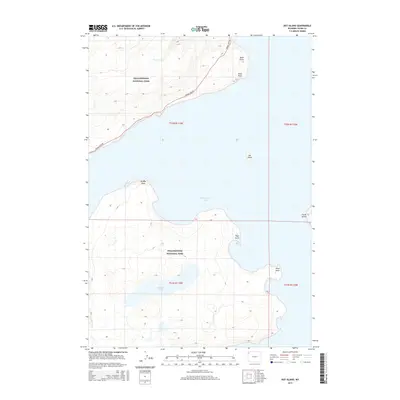
2015 Map of Dot Island
USGS Topo · Published 2015About this map
Yellowstone Lake dominates this 2015 survey, revealing a landscape defined by its intricate shoreline and high-altitude hydrology within Yellowstone National Park. The map details a series of distinctive landforms reaching into the water, including Sand Point, Rock Point, and the prominent Breeze Point. In the center of the lake, Dot Island serves as a lone navigation marker, while the much larger Frank Island sits to the east. Inland, the hydrology is shaped by Delusion Lake and the drainage of Weasel Cr, illustrating the complex water systems of the Teton County plateau. The Grand Loop Rd skirts the northwestern shore, representing the primary human artery through this wilderness, providing access to the various points and overlooks that have defined the park experience for generations of visitors.
Find a feature on this map
17 named features on this map. Tap any name to fly to it.
Don’t see what you’re looking for? This feature index may not catch every label — zoom into the map to look around manually.
Map Details
Editions of this 2015 Dot Island Map
This is the sole edition of this map. No revisions or reprints were ever made.
Other maps of this area

1885 · Lake
USGS Topo · 1:125,000

1885 · Gallatin
USGS Topo · 1:125,000

1885 · Gallatin
USGS Topo · 1:125,000

1886 · Shoshone
USGS Topo · 1:125,000

1886 · Canyon
USGS Topo · 1:125,000

1888 · Shoshone
USGS Topo · 1:125,000

1895 · Shoshone
USGS Topo · 1:125,000

1895 · Canyon
USGS Topo · 1:125,000

1895 · Lake
USGS Topo · 1:125,000

1896 · Lake
USGS Topo · 1:125,000