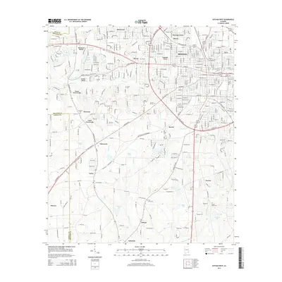
2014 Map of Dothan West
USGS Topo · Published 2014About this map
The western expansion of Dothan dominates this modern topographical study, revealing the dense residential growth and commercial corridors that have shaped this portion of Houston Co. Primary thoroughfares like the Hartford Hwy and W State Highway 52 serve as the backbone for numerous neighborhoods, including Bel Air, Lamont Court, and Green Acres. Beyond the city limits, the landscape transitions into a network of established rural communities and historically significant crossroads such as Jones Crossroads and Clark Crossroads.
Find a feature on this map
49 named features on this map. Tap any name to fly to it.
Don’t see what you’re looking for? This feature index may not catch every label — zoom into the map to look around manually.
Map Details
Editions of this 2014 Dothan West Map
This is the sole edition of this map. No revisions or reprints were ever made.
Other maps of this area

1942 · Enterprise
USGS Topo · 1:125,000

1948 · Ozark
USGS Topo · 1:62,500

1950 · Ozark
USGS Topo · 1:62,500

1953 · Dothan
USGS Topo · 1:250,000

1954 · Dothan
USGS Topo · 1:250,000

1955 · Dothan
USGS Topo · 1:250,000

1957 · Malvern
USGS Topo · 1:24,000

1957 · Hartford
USGS Topo · 1:62,500
1957 · Slocomb
USGS Topo · 1:24,000

1960 · Pinckard
USGS Topo · 1:24,000