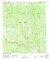
1988 Map of Double Buttes
USGS Topo · Published 1988About this map
The Fort Apache Indian Reservation defines this landscape in central Arizona, where a complex network of canyons and ridges dictates the movement of water and wildlife. The winding course of Canyon Creek serves as a primary drainage, joined by seasonal flows from Sloan Creek, Oak Creek, and Willow Creek. Numerous localized water sources, such as Wild Nut Spring, Deer Spring, and Whitetail Spring, indicate the vital role of specific springs in this arid environment. The map shows a high density of man-made water catchments across the terrain, including Double Buttes Tank, Keystone Tank, and Mustang Ridge Tank, which support ranching or game management within the reservation. Geographic landmarks like Double Buttes and the prominent Keystone Ridge provide navigation points across the rugged topography, while the Navajo Co Gila Co boundary line runs along the northern edge of the survey.
Find a feature on this map
27 named features on this map. Tap any name to fly to it.
Don’t see what you’re looking for? This feature index may not catch every label — zoom into the map to look around manually.
Map Details
Editions of this 1988 Double Buttes Map
This is the sole edition of this map. No revisions or reprints were ever made.
Other maps of this area

1886 · Holbrook
USGS Topo · 1:250,000

1893 · Holbrook
USGS Topo · 1:250,000

1922 · Chrysotile
USGS Topo · 1:125,000

1946 · Blue House Mtn
USGS Topo · 1:62,500

1949 · McFadden Peak
USGS Topo · 1:62,500

1950 · McFadden Peak
USGS Topo · 1:62,500

1951 · Blue House Mtn
USGS Topo · 1:62,500

1954 · Holbrook
USGS Topo · 1:250,000

1954 · Mesa
USGS Topo · 1:250,000

1957 · Mesa
USGS Topo · 1:250,000