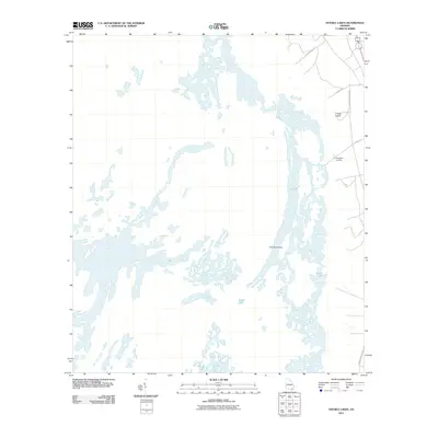
2011 Map of Double Lakes
USGS Topo · Published 2011About this map
Kingfisher Landing provides a rare point of access to the intricate wetland systems of Charlton County in this 2011 survey. The landscape is defined by its complex hydrography, where shallow bodies of water like Perch Lake, Sand Lake, and House Lake are interspersed among subtle terrain elevations. These higher ground features, including Pine Hammock and Grassy Island, reveal the natural patterns of the Georgia swampland before the modern era. Navigation through this environment is restricted to a limited network of corridors such as Swamp Perimeter Rd and Canal Rd, illustrating the intersection of human infrastructure and the persistent, water-heavy geography of the region.
Find a feature on this map
10 named features on this map. Tap any name to fly to it.
Don’t see what you’re looking for? This feature index may not catch every label — zoom into the map to look around manually.
Map Details
Editions of this 2011 Double Lakes Map
This is the sole edition of this map. No revisions or reprints were ever made.
Other maps of this area

1918 · Folkston
USGS Topo · 1:62,500

1953 · Waycross
USGS Topo · 1:250,000

1954 · Valdosta
USGS Topo · 1:250,000

1958 · Valdosta
USGS Topo · 1:250,000

1958 · Waycross
USGS Topo · 1:250,000

1959 · Valdosta
USGS Topo · 1:250,000

1965 · Double Lakes
USGS Topo · 1:24,000

1965 · Chase Prairie
USGS Topo · 1:24,000

1965 · Dinner Pond
USGS Topo · 1:24,000
1966 · Billys Island
USGS Topo · 1:24,000