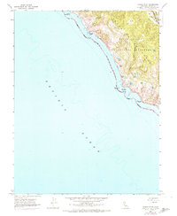
1954 Map of Double Point
USGS Topo · Published 1955About this map
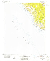
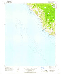
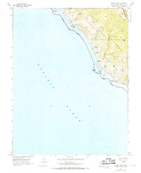
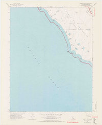
Punta De Los Reyes (Sobrante) dominates this coastal survey, where the terrestrial landscape of Marin County meets the Pacific Ocean. This mid-century view captures a series of notable freshwater bodies set just inland from the sea, including Wildcat Lake, Ocean Lake, Crystal Lake, Pelican Lake, and Bass Lake. The geography is defined by the significant geological presence of the San Andreas Rift Zone, which runs parallel to the coast near the drainage of Olema Creek. Human activity is concentrated along the Tomales Y Baulines (Garcias) Road and at the Lake Ranch settlement. The map also delineates the Wildcat Military Res, reflecting the strategic importance of this coastline in the post-war era. The terrain transitions from the shoreline at Double Point to the sheltered interior of Bear Valley, providing a detailed look at the peninsula's complex hydrology and land use before widespread modern development.
Find a feature on this map
17 named features on this map. Tap any name to fly to it.
Don’t see what you’re looking for? This feature index may not catch every label — zoom into the map to look around manually.
Map Details
Editions of this 1954 Double Point Map
7 editions found
Historical Maps of Marin County Through Time
58 maps found

1897 Tamalpais
Marin County, CA

1916 Point Reyes
Marin County, CA

1918 Point Reyes
Marin County, CA

1941 Tamalpais
Marin County, CA

1947 San Quentin
Marin County, CA

1948 San Quentin
Marin County, CA

1950 Mt. Tamalpais
Marin County, CA

1951 Petaluma Point
Marin County, CA

1953 Drakes Bay
Marin County, CA

1954 Double Point
Marin County, CA

1954 Point Bonita
Marin County, CA

1954 Point Reyes
Marin County, CA

1954 Point Reyes NE
Marin County, CA

1959 Petaluma Point
Marin County, CA

1959 San Quentin
Marin County, CA

1993 Double Point
Marin County, CA

1993 Point Bonita
Marin County, CA

1993 San Quentin
Marin County, CA

1994 Double Point
Marin County, CA

1995 Drakes Bay
Marin County, CA

1995 Point Reyes NE
Marin County, CA

1995 San Quentin
Marin County, CA

2012 Double Point
Marin County, CA

2012 Drakes Bay
Marin County, CA

2012 Drakes Bay OE S
Marin County, CA

2012 Drakes Bay OE SW
Marin County, CA

2012 Drakes Bay OE W
Marin County, CA

2012 Petaluma Point
Marin County, CA

2012 Point Bonita
Marin County, CA

2012 Point Reyes NE
Marin County, CA

2012 San Quentin
Marin County, CA

2015 Double Point
Marin County, CA

2015 Drakes Bay
Marin County, CA

2015 Drakes Bay OE S
Marin County, CA

2015 Drakes Bay OE SW
Marin County, CA

2015 Drakes Bay OE W
Marin County, CA

2015 Petaluma Point
Marin County, CA

2015 Point Bonita
Marin County, CA

2015 Point Reyes NE
Marin County, CA

2015 San Quentin
Marin County, CA

2018 Double Point
Marin County, CA

2018 Drakes Bay
Marin County, CA

2018 Drakes Bay OE S
Marin County, CA

2018 Drakes Bay OE SW
Marin County, CA

2018 Drakes Bay OE W
Marin County, CA

2018 Petaluma Point
Marin County, CA

2018 Point Bonita
Marin County, CA

2018 Point Reyes NE
Marin County, CA

2018 San Quentin
Marin County, CA

2021 Double Point
Marin County, CA

2021 Drakes Bay
Marin County, CA

2021 Drakes Bay OE S
Marin County, CA

2021 Drakes Bay OE SW
Marin County, CA

2021 Drakes Bay OE W
Marin County, CA

2021 Point Bonita
Marin County, CA

2021 Point Reyes NE
Marin County, CA

2021 San Quentin
Marin County, CA

2022 Petaluma Point
Marin County, CA