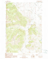
1989 Map of Doublespring
USGS Topo · Published 1989About this map
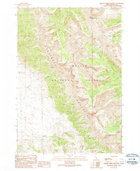
The Pahsimeroi Mountains dominate this high-altitude landscape of central Idaho, where the rugged peaks of the Challis National Forest descend into the broad Pahsimeroi Valley. The terrain is defined by dramatic elevation changes, carved by drainages such as Christian Gulch, Dead Canyon, and Buck Creek. This late 1980s provisional survey shows a wilderness largely characterized by its vertical relief, with the Doublespring Ranch serving as one of the few named sites of human habitation in the valley. In the southern reaches of the quadrangle, Carlson Lake sits tucked away in the high country, while Doublespring Creek flows northeast toward the valley floor. The sparse distribution of infrastructure and named features reflects the remote character of Custer County during this era.
Find a feature on this map
11 named features on this map. Tap any name to fly to it.
Don’t see what you’re looking for? This feature index may not catch every label — zoom into the map to look around manually.
Map Details
Editions of this 1989 Doublespring Map
This is the sole edition of this map. No revisions or reprints were ever made.
Other maps of this area

1935 · Borah Peak
USGS Topo · 1:125,000

1938 · Borah Peak
USGS Topo · 1:125,000

1955 · Dubois
USGS Topo · 1:250,000

1956 · Donkey Hills
USGS Topo · 1:62,500

1956 · Doublespring
USGS Topo · 1:62,500

1958 · Dubois
USGS Topo · 1:250,000
1967 · Burnt Creek
USGS Topo · 1:24,000
1967 · Borah Peak
USGS Topo · 1:24,000
1967 · Dickey Peak
USGS Topo · 1:24,000
1989 · Grouse Creek Mountain
USGS Topo · 1:24,000