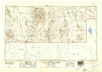
1955 Map of Douglas
USGS Topo · Published 1955About this map
Bisbee and the surrounding Mule Mountains anchor this mid-century look at the Arizona-Mexico borderlands, where the mining economy and cattle ranching define the landscape. The intricate topography reveals the copper-rich districts of Lowell and Warren near the border, alongside the international gateway of Douglas. To the east, the rugged peaks of the Chiricahua Mountains and the Chiricahua National Monument dominate the horizon, while the wide Sulphur Spring Valley provides room for agricultural outposts like Elfrida and McNeal.
Find a feature on this map
168 named features on this map. Tap any name to fly to it.
Don’t see what you’re looking for? This feature index may not catch every label — zoom into the map to look around manually.
Map Details
Editions of this 1955 Douglas Map
2 editions found

Other maps of this area

1899 · Deming
USGS Topo · 1:125,000

1902 · Bisbee
USGS Topo · 1:62,500

1910 · Bisbee
USGS Topo · 1:62,500

1914 · Hereford
USGS Topo · 1:125,000

1914 · Douglas
USGS Topo · 1:62,500

1915 · Benson
USGS Topo · 1:125,000

1915 · Deming
USGS Topo · 1:125,000

1916 · Pearce
USGS Topo · 1:125,000

1916 · Douglas
USGS Topo · 1:125,000

1917 · Hermanas
USGS Topo · 1:62,500