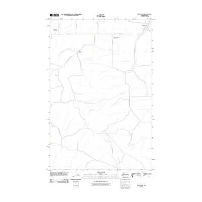
2011 Map of Douglas
USGS Topo · Published 2011About this map
The settlement of Douglas sits in the northeast corner of this Douglas County quadrangle, where Douglas Creek cuts through the high plateau. The landscape is defined by a series of deep drainages and canyons that break up the grid of agricultural roads, including McGinnis Canyon and Ruud Canyon. This 2011 survey by the U.S. Geological Survey illustrates the transition from the rolling upland plains to the sharp relief of the creek beds. One of the few designated landmarks on this map is the Badger Mountain Cemetery, located south of Baseline Rd. The drainage network is complex, featuring the convergence of North Fork Paine Creek and South Fork Paine Creek into the main branch of Paine Creek, alongside Duffy Creek further south. The map provides a detailed view of the local road system, including routes like Indian Camp Rd and Titchenal Canyon Rd SW, which navigate the challenging terrain between the canyons.
Find a feature on this map
23 named features on this map. Tap any name to fly to it.
Don’t see what you’re looking for? This feature index may not catch every label — zoom into the map to look around manually.
Map Details
Editions of this 2011 Douglas Map
This is the sole edition of this map. No revisions or reprints were ever made.
Other maps of this area

1901 · Chelan
USGS Topo · 1:125,000

1912 · Malaga
USGS Topo · 1:48,000

1914 · Malaga
USGS Topo · 1:62,500

1920 · Colockum Pass
USGS Topo · 1:125,000

1922 · Colockum Pass
USGS Topo · 1:125,000

1953 · Ritzville
USGS Topo · 1:250,000

1957 · Wenatchee
USGS Topo · 1:250,000

1959 · Ritzville
USGS Topo · 1:250,000

1965 · Ritzville
USGS Topo · 1:250,000
1966 · Palisades
USGS Topo · 1:24,000