1968 Map of Douglas
USGS Topo · Published 1972About this map
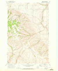
Douglas sits on the northeastern edge of this late-1960s survey, a small settlement located where the Burlington Northern railroad meets the winding course of Douglas Creek. The landscape is dominated by the dramatic elevation change between the high, relatively flat Waterville Plateau and the deeply incised drainage systems of Badger Mountain. This transition is marked by numerous seasonal flows and steep ravines, such as Titchenal Canyon and Ruud Canyon, which illustrate the erosion patterns characteristic of this part of Washington. Local history and genealogy interest is anchored by the Badger Mtn Cem and several family-named landmarks like Bevington Canyon and McGinnis Canyon. The presence of a Gaging Station and various storage bins reflects the area's ongoing management of water resources and agricultural output during this era.
Find a feature on this map
25 named features on this map. Tap any name to fly to it.
Don’t see what you’re looking for? This feature index may not catch every label — zoom into the map to look around manually.
Map Details
Editions of this 1968 Douglas Map
2 editions found
Historical Maps of Douglas Through Time
65 maps found

1912 Malaga
Douglas County, WA

1914 Malaga
Douglas County, WA

1965 Jameson Lake East
Douglas County, WA

1965 Jameson Lake SE
Douglas County, WA

1965 Jameson Lake SW
Douglas County, WA

1965 Jameson Lake West
Douglas County, WA

1965 Mold
Douglas County, WA

1965 St. Andrews
Douglas County, WA

1966 Malaga NE
Douglas County, WA

1966 Palisades
Douglas County, WA

1966 Rattlesnake Springs
Douglas County, WA

1966 Rock Island Dam
Douglas County, WA

1968 Alstown
Douglas County, WA

1968 Barker Canyon
Douglas County, WA

1968 Barnes Butte
Douglas County, WA

1968 Chief Joseph Dam
Douglas County, WA

1968 Coleman Hill
Douglas County, WA

1968 Douglas
Douglas County, WA

1968 Farmer
Douglas County, WA

1968 Foster Coulee
Douglas County, WA

1968 Lamoine
Douglas County, WA

1968 Leahy
Douglas County, WA

1968 Mud Spring
Douglas County, WA

1968 Orondo
Douglas County, WA

1968 Piersol Hills
Douglas County, WA

1968 Sims Corner
Douglas County, WA

1968 Wells Dam
Douglas County, WA

1968 Withrow
Douglas County, WA

1980 Trefry Canyon
Douglas County, WA

1981 Stubblefield Point
Douglas County, WA

1985 Sagebrush Flat
Douglas County, WA

1989 Alameda Flat
Douglas County, WA

1989 Sanderson Creek
Douglas County, WA

2003 Orondo
Douglas County, WA

2023 Alameda Flat
Douglas County, WA

2023 Alstown
Douglas County, WA

2023 Barker Canyon
Douglas County, WA

2023 Barnes Butte
Douglas County, WA

2023 Chief Joseph Dam
Douglas County, WA

2023 Coleman Hill
Douglas County, WA

2023 Douglas
Douglas County, WA

2023 Farmer
Douglas County, WA

2023 Foster Coulee
Douglas County, WA

2023 Jameson Lake East
Douglas County, WA

2023 Jameson Lake SE
Douglas County, WA

2023 Jameson Lake SW
Douglas County, WA

2023 Jameson Lake West
Douglas County, WA

2023 Lamoine
Douglas County, WA

2023 Leahy
Douglas County, WA

2023 Malaga NE
Douglas County, WA

2023 Mold
Douglas County, WA

2023 Mud Spring
Douglas County, WA

2023 Orondo
Douglas County, WA

2023 Palisades
Douglas County, WA

2023 Piersol Hills
Douglas County, WA

2023 Rattlesnake Springs
Douglas County, WA

2023 Rock Island Dam
Douglas County, WA

2023 Sagebrush Flat
Douglas County, WA

2023 Saint Andrews
Douglas County, WA

2023 Sanderson Creek
Douglas County, WA

2023 Sims Corner
Douglas County, WA

2023 Stubblefield Point
Douglas County, WA

2023 Trefry Canyon
Douglas County, WA

2023 Wells Dam
Douglas County, WA

2023 Withrow
Douglas County, WA