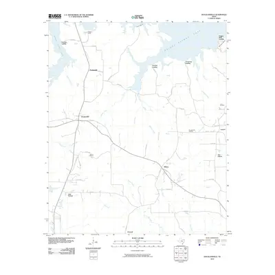
2010 Map of Douglassville
USGS Topo · Published 2010About this map
Douglassville and its surrounding rural landscapes in Cass County are defined by the expansive waters of Wright Patman Lake and a network of named creeks. This 2010 topographic record captures the eastern Texas countryside, where small settlements like O'Farrell, Gum Springs, and New Liberty are connected by a web of county roads and farm-to-market routes. The shoreline of the lake is punctuated by several access points, including Knights Bluff Landing and Poorboy Landing, reflecting the area's transition from traditional agriculture to lakeside recreation. Local history is anchored by the Rutland Cemetery and Liberty Cemetery, while the Douglassville Lookout provides a distinct landmark near the town center. Numerous drainages such as Shoal Creek, Ellington Creek, and Bee Creek carve through the terrain, illustrating the hydrologic patterns that have shaped the region's development since its early settlement.
Find a feature on this map
63 named features on this map. Tap any name to fly to it.
Don’t see what you’re looking for? This feature index may not catch every label — zoom into the map to look around manually.
Map Details
Editions of this 2010 Douglassville Map
This is the sole edition of this map. No revisions or reprints were ever made.
Other maps of this area

1907 · Atlanta
USGS Topo · 1:62,500

1909 · New Boston
USGS Topo · 1:62,500

1909 · Texarkana
USGS Topo · 1:62,500

1910 · Linden
USGS Topo · 1:62,500

1910 · Atlanta
USGS Topo · 1:62,500

1953 · Texarkana
USGS Topo · 1:250,000

1954 · Lake Texarkana
USGS Topo · 1:24,000
1954 · Texarkana
USGS Topo · 1:62,500

1955 · Corley
USGS Topo · 1:24,000

1955 · Maud
USGS Topo · 1:24,000