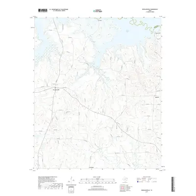
2019 Map of Douglassville
USGS Topo · Published 2019About this map
Douglassville serves as the central hub of this northeast Texas landscape, situated just south of the Wright Patman Lake reservoir. The terrain is defined by a dense network of winding creeks and branches, including Douglassville Cr, Webster Cr, and Ellington Cr, which drain northward toward the lake and the Bowie Co line. Elevated features like Pine Bluff and Knights Bluff overlook the water, offering a contrast to the lower creek bottoms.
Find a feature on this map
72 named features on this map. Tap any name to fly to it.
Don’t see what you’re looking for? This feature index may not catch every label — zoom into the map to look around manually.
Map Details
Editions of this 2019 Douglassville Map
This is the sole edition of this map. No revisions or reprints were ever made.
Other maps of this area

1907 · Atlanta
USGS Topo · 1:62,500

1909 · New Boston
USGS Topo · 1:62,500

1909 · Texarkana
USGS Topo · 1:62,500

1910 · Linden
USGS Topo · 1:62,500

1910 · Atlanta
USGS Topo · 1:62,500

1953 · Texarkana
USGS Topo · 1:250,000

1954 · Lake Texarkana
USGS Topo · 1:24,000
1954 · Texarkana
USGS Topo · 1:62,500

1955 · Corley
USGS Topo · 1:24,000

1955 · Maud
USGS Topo · 1:24,000