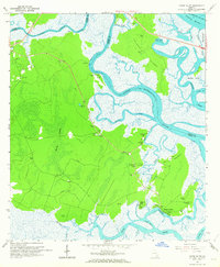
1961 Map of Dover Bluff
USGS Topo · Published 1963About this map
The Little Satilla River and Dover Creek define this coastal landscape, where the tides weave through Colonels Island and Black Hammock. Inland from the marshes, the terrain transitions into the dense Hardy Swamp, marked by numerous flowing wells that hint at the underlying hydrology of the Georgia coast. Local history is deeply embedded in the land, from the Indian Mounds near Sparkman Creek to the site of the Old Spanish Mission located just north of Dover Bluff.
Find a feature on this map
40 named features on this map. Tap any name to fly to it.
Don’t see what you’re looking for? This feature index may not catch every label — zoom into the map to look around manually.
Map Details
Editions of this 1961 Dover Bluff Map
This is the sole edition of this map. No revisions or reprints were ever made.
Other maps of this area

1918 · Cumberland Island
USGS Topo · 1:62,500

1918 · Bladen
USGS Topo · 1:62,500

1918 · Kingsland
USGS Topo · 1:62,500

1930 · Cumberland Island
USGS Topo · 1:62,500

1939 · Bladen
USGS Topo · 1:62,500

1945 · Brunswick
USGS Topo · 1:62,500

1945 · Cumberland Island
USGS Topo · 1:62,500

1946 · Brunswick
USGS Topo · 1:250,000

1948 · Jacksonville
USGS Topo · 1:250,000

1948 · Brunswick
USGS Topo · 1:250,000