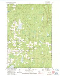
1979 Map of Dover
USGS Topo · Published 1991About this map
The Chequamegon National Forest covers much of this landscape in Price County, where the transition from timber harvesting to recreational and rural life is evident. Evidence of the region's logging heritage is preserved in the winding path of the Old Railroad Grade, which once facilitated the movement of timber through the townships of Worcester, Emery, and Hackett. These townships are defined by a network of local roads such as Musser Drive and Evergreen Road, connecting small clusters of habitation and resource extraction sites.
Find a feature on this map
25 named features on this map. Tap any name to fly to it.
Don’t see what you’re looking for? This feature index may not catch every label — zoom into the map to look around manually.
Map Details
Editions of this 1979 Dover Map
3 editions found
Other maps of this area

1941 · Park Falls
USGS Topo · 1:48,000

1941 · Pike Lake
USGS Topo · 1:48,000

1941 · Phillips
USGS Topo · 1:48,000

1941 · Brantwood
USGS Topo · 1:48,000

1942 · Pike Lake
USGS Topo · 1:48,000

1943 · Park Falls
USGS Topo · 1:48,000

1943 · Philliips
USGS Topo · 1:48,000

1943 · Brantwood
USGS Topo · 1:48,000

1947 · Park Falls
USGS Topo · 1:48,000

1950 · Pike Lake
USGS Topo · 1:48,000