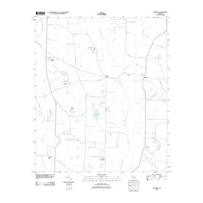
2011 Map of Doverel
USGS Topo · Published 2011About this map
Ichawaynochaway Creek and its tributaries, Walk-Ikey Creek and Falling Creek, carve a drainage pattern across this rural Randolph County landscape. The area is defined by a series of significant water bodies and man-made impoundments, including Hundred Acre Pond, Rice Lake, and Bynum Lake. The small community of Doverel sits near the intersection of several county roads, while Five Points serves as a local navigational landmark. Cultural and genealogical sites are scattered throughout the agricultural terrain, notably the Bethlehem Freewill Baptist Church Cemetery and the Collier Cemetery. The inclusion of Aycock Mill on Pruitt Creek points to the long-standing water-powered industry that once supported this corner of southwest Georgia.
Find a feature on this map
49 named features on this map. Tap any name to fly to it.
Don’t see what you’re looking for? This feature index may not catch every label — zoom into the map to look around manually.
Map Details
Editions of this 2011 Doverel Map
This is the sole edition of this map. No revisions or reprints were ever made.
Other maps of this area

1953 · Dothan
USGS Topo · 1:250,000

1954 · Dothan
USGS Topo · 1:250,000

1955 · Dothan
USGS Topo · 1:250,000

1956 · Sasser
USGS Topo · 1:62,500

1972 · Shellman
USGS Topo · 1:24,000
1972 · Brooksville
USGS Topo · 1:24,000

1973 · Morgan
USGS Topo · 1:24,000

1973 · Chickasawhatchee
USGS Topo · 1:24,000

1973 · Martins Crossroads
USGS Topo · 1:24,000

1973 · Dawson
USGS Topo · 1:24,000