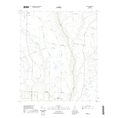
2020 Map of Doverel
USGS Topo · Published 2020About this map
The agricultural landscape of Southwest Georgia unfolds across the meeting point of Randolph, Terrell, and Calhoun counties. The settlement of Shellman occupies the northwestern corner, while the small crossroads of Five Points and Doverel anchor the eastern side of the survey. The terrain is defined by a complex network of wetlands and namesake water bodies, including Chickasawhatchee Creek and Falling Creek, which flow through a region dotted with numerous natural depressions such as Hundred Acre Pond, Rice Lake, and Bynum Lake. Local history is preserved in the placement of the Bethelem Freewill Baptist Church Cem and the Collier Cem. Traces of earlier industry and commerce remain visible through landmarks like Aycock Mill and rural thoroughfares such as Noc-Nasty Rd and Settle Store Rd, reflecting a long-standing rural community structure centered on farming and small-scale milling operations.
Find a feature on this map
59 named features on this map. Tap any name to fly to it.
Don’t see what you’re looking for? This feature index may not catch every label — zoom into the map to look around manually.
Map Details
Editions of this 2020 Doverel Map
This is the sole edition of this map. No revisions or reprints were ever made.
Other maps of this area

1953 · Dothan
USGS Topo · 1:250,000

1954 · Dothan
USGS Topo · 1:250,000

1955 · Dothan
USGS Topo · 1:250,000

1956 · Sasser
USGS Topo · 1:62,500

1972 · Shellman
USGS Topo · 1:24,000
1972 · Brooksville
USGS Topo · 1:24,000

1973 · Morgan
USGS Topo · 1:24,000

1973 · Chickasawhatchee
USGS Topo · 1:24,000

1973 · Martins Crossroads
USGS Topo · 1:24,000

1973 · Dawson
USGS Topo · 1:24,000