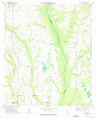
1973 Map of Doverel
USGS Topo · Published 1975About this map
Ichawaynochaway Creek forms a prominent natural boundary between Randolph and Terrell counties, carving a broad, low-lying basin through this agricultural landscape. The 1970s terrain is marked by a dense network of country churches that served as the social anchors for rural families, including Enterprise Ch, Salem Ch, and Bethlehem Ch. The small settlement of Doverel sits near the eastern edge, while the town of Shellman occupies the northwestern corner, connected by a series of improved and light-duty roads that navigate around numerous sandpits and wetlands.
Find a feature on this map
24 named features on this map. Tap any name to fly to it.
Don’t see what you’re looking for? This feature index may not catch every label — zoom into the map to look around manually.
Map Details
Editions of this 1973 Doverel Map
This is the sole edition of this map. No revisions or reprints were ever made.
Other maps of this area

1953 · Dothan
USGS Topo · 1:250,000

1954 · Dothan
USGS Topo · 1:250,000

1955 · Dothan
USGS Topo · 1:250,000

1956 · Sasser
USGS Topo · 1:62,500

1972 · Shellman
USGS Topo · 1:24,000
1972 · Brooksville
USGS Topo · 1:24,000

1973 · Morgan
USGS Topo · 1:24,000

1973 · Chickasawhatchee
USGS Topo · 1:24,000

1973 · Martins Crossroads
USGS Topo · 1:24,000

1973 · Dawson
USGS Topo · 1:24,000