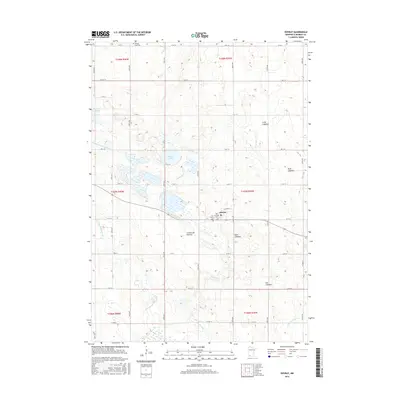
2016 Map of Dovray
USGS Topo · Published 2016About this map
The Coteau des Prairies plateau dominates this section of Murray County, where the village of Dovray sits at the junction of Co Hwy 41 and 141st St. The landscape is a complex network of glacial remnants, characterized by numerous lakebeds and drainage features. The headwaters of the Des Moines River and its tributaries, such as Devils Run and Dutch Charley Cr, weave through the township lines of t107n r40w and t107n r39w. Genealogists will find several burial sites including Our Saviors Cem and Old German Cem near the town center, along with Willow Lake Cem to the north. Significant water features like Buffalo Lake and Willow Lake persist alongside several large depressions labeled as Long Lakebed and Rush Lakebed, indicating the area's historical hydrology and seasonal shifts in water levels.
Find a feature on this map
37 named features on this map. Tap any name to fly to it.
Don’t see what you’re looking for? This feature index may not catch every label — zoom into the map to look around manually.
Map Details
Editions of this 2016 Dovray Map
This is the sole edition of this map. No revisions or reprints were ever made.
Other maps of this area

1953 · New Ulm
USGS Topo · 1:250,000

1954 · Fairmont
USGS Topo · 1:250,000

1957 · New Ulm
USGS Topo · 1:250,000

1958 · New Ulm
USGS Topo · 1:250,000

1958 · Fairmont
USGS Topo · 1:250,000

1967 · New Ulm
USGS Topo · 1:250,000

1967 · Walnut Grove
USGS Topo · 1:24,000

1967 · Tracy East
USGS Topo · 1:24,000
1967 · Tracy West
USGS Topo · 1:24,000

1967 · Dovray
USGS Topo · 1:24,000