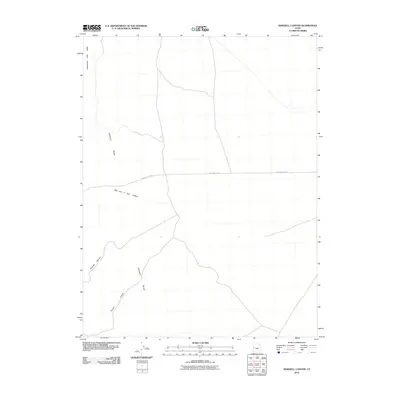
2010 Map of Dowdell Canyon
USGS Topo · Published 2010About this map
The Confusion Range dominates this arid landscape in Millard County, Utah, providing a detailed look at the topographic structure of the Great Basin. This 2010 survey delineates several prominent drainages, including the lengthy Dowdell Canyon and Payson Canyon, which cut through the uplifted terrain. The presence of Cattlemens Little Valley suggests a history of grazing and ranching activity in the northern portion of the quadrangle. Transport through this remote area is primarily facilitated by the east-west passage of Mile and 1/2 Rd, which intersects with the north-south routes through Mile and a Half Canyon. The map serves as a precise record of the road and trail network as it existed at the start of the decade, reflecting the sparse infrastructure characteristic of this high-desert environment.
Find a feature on this map
6 named features on this map. Tap any name to fly to it.
Don’t see what you’re looking for? This feature index may not catch every label — zoom into the map to look around manually.
Map Details
Editions of this 2010 Dowdell Canyon Map
This is the sole edition of this map. No revisions or reprints were ever made.
Other maps of this area

1908 · Fish Springs
USGS Topo · 1:250,000

1910 · Fish Springs
USGS Topo · 1:250,000

1953 · Delta
USGS Topo · 1:250,000

1958 · Delta
USGS Topo · 1:250,000

1959 · Cowboy Pass
USGS Topo · 1:62,500

1960 · Notch Peak
USGS Topo · 1:62,500

1960 · Conger Mountain
USGS Topo · 1:62,500

1962 · Delta
USGS Topo · 1:250,000

1972 · Swasey Peak SW
USGS Topo · 1:24,000
1981 · Tule Valley
USGS Topo · 1:100,000