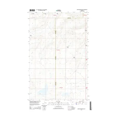
2014 Map of Down Reservoir NE
USGS Topo · Published 2014About this map
The boundary between Blaine Co and Phillips Co bisects this northern Montana landscape, defined by a series of drainage features known as coulees. Flowing through the high plains, Little Jewel Coulee and Black Coulee carve through the northern sections, while Reservoir Coulee and Coburg Coulee dominate the central and eastern portions. The area is largely defined by its topography and the section-line grid system, with very little modern development beyond the lone track of Nicholson Dr. This map illustrates the transition from the higher terrain in the north toward the lower basins in the south, where small, unnamed water bodies collect at the base of the coulees, providing a record of the natural watershed before reaching the Milk River valley further south.
Find a feature on this map
12 named features on this map. Tap any name to fly to it.
Don’t see what you’re looking for? This feature index may not catch every label — zoom into the map to look around manually.
Map Details
Editions of this 2014 Down Reservoir NE Map
This is the sole edition of this map. No revisions or reprints were ever made.
Other maps of this area

1920 · Avery
USGS Topo · 1:125,000

1953 · Havre
USGS Topo · 1:250,000

1957 · Havre
USGS Topo · 1:250,000

1958 · Havre
USGS Topo · 1:250,000

1984 · Chapman
USGS Topo · 1:24,000

1984 · Emerick Bench
USGS Topo · 1:24,000

1984 · Turner
USGS Topo · 1:24,000
1984 · Hubert Hill SW
USGS Topo · 1:24,000
1984 · Down Reservoir NW
USGS Topo · 1:24,000
1984 · Down Reservoir NE
USGS Topo · 1:24,000