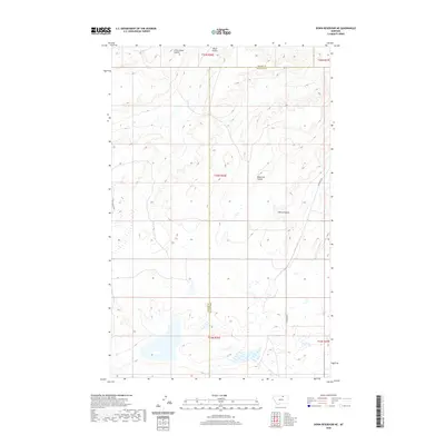
2020 Map of Down Reservoir NE
USGS Topo · Published 2020About this map
Little Jewel Coulee and Black Coulee carve through this section of the northern Montana plains, defining a landscape shaped by seasonal drainage and ranching geography. This 2020 survey captures the boundary where Blaine County and Phillips County meet, showing the rectilinear township and range system that governs the modern land use here. The terrain is marked by distinct topographical depressions such as Reservoir Coulee and Coburg Coulee, which serve as natural landmarks in an area otherwise characterized by high-elevation prairie and scattered wetlands. Human infrastructure is limited to essential connectors like Black Coulee Rd and N Dodson Rd, reflecting the remote, agrarian character of the region. The map provides a detailed view of the hydrography and surface features crucial for understanding the local environment near the Canadian border.
Find a feature on this map
12 named features on this map. Tap any name to fly to it.
Don’t see what you’re looking for? This feature index may not catch every label — zoom into the map to look around manually.
Map Details
Editions of this 2020 Down Reservoir NE Map
This is the sole edition of this map. No revisions or reprints were ever made.
Other maps of this area

1920 · Avery
USGS Topo · 1:125,000

1953 · Havre
USGS Topo · 1:250,000

1957 · Havre
USGS Topo · 1:250,000

1958 · Havre
USGS Topo · 1:250,000

1984 · Chapman
USGS Topo · 1:24,000

1984 · Emerick Bench
USGS Topo · 1:24,000

1984 · Turner
USGS Topo · 1:24,000
1984 · Hubert Hill SW
USGS Topo · 1:24,000
1984 · Down Reservoir NW
USGS Topo · 1:24,000
1984 · Down Reservoir NE
USGS Topo · 1:24,000