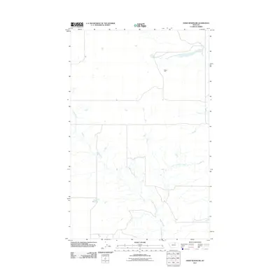
2011 Map of Down Reservoir
USGS Topo · Published 2011About this map
Down Reservoir and its surrounding water network define this section of the Montana landscape, captured during a 2011 survey by the U.S. Geological Survey. The geography is shaped by the drainage patterns of Dodson Creek and its tributary, the North Fork Dodson Creek, which meander through the terrain. A notable point of water management on the sheet is Rocky Dam, situated along the northern reach of the fork. This map documents the rural hydrology and road infrastructure in a region where water sources and catchments are central to land use and local identity.
Find a feature on this map
4 named features on this map. Tap any name to fly to it.
Don’t see what you’re looking for? This feature index may not catch every label — zoom into the map to look around manually.
Map Details
Editions of this 2011 Down Reservoir Map
This is the sole edition of this map. No revisions or reprints were ever made.
Other maps of this area

1920 · Avery
USGS Topo · 1:125,000

1953 · Havre
USGS Topo · 1:250,000

1957 · Havre
USGS Topo · 1:250,000

1958 · Havre
USGS Topo · 1:250,000

1964 · Coburg
USGS Topo · 1:24,000

1964 · Dodson
USGS Topo · 1:24,000

1964 · Dodson Dam
USGS Topo · 1:24,000

1984 · Emerick Bench
USGS Topo · 1:24,000
1984 · Hubert Hill SW
USGS Topo · 1:24,000
1984 · Down Reservoir NW
USGS Topo · 1:24,000