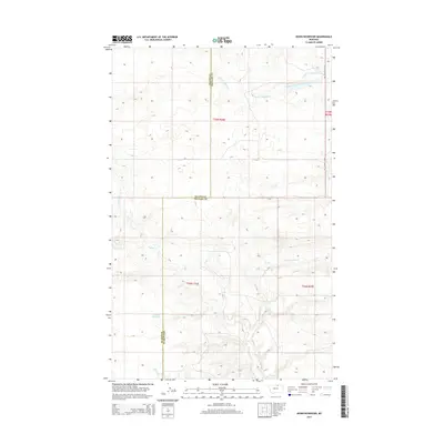
2014 Map of Down Reservoir
USGS Topo · Published 2014About this map
Down Reservoir sits near the southern edge of this section of the Montana high plains, where the terrain is defined by the winding drainage systems of the Milk River watershed. The boundary between Blaine County and Phillips County bisects the landscape vertically, marking a jurisdictional divide across a largely open prairie used for ranching and water management. Much of the hydraulic character of the area is shaped by the Dodson Creek system, including its northern branches like North Fork Dodson Creek and N Fork Dodson Cr. Apart from the primary water features, the map shows very little modern development, with Black Coulee Rd providing one of the few named navigational routes through the expansive township and range divisions of t33n r26e and t32n r27e.
Find a feature on this map
10 named features on this map. Tap any name to fly to it.
Don’t see what you’re looking for? This feature index may not catch every label — zoom into the map to look around manually.
Map Details
Editions of this 2014 Down Reservoir Map
This is the sole edition of this map. No revisions or reprints were ever made.
Other maps of this area

1920 · Avery
USGS Topo · 1:125,000

1953 · Havre
USGS Topo · 1:250,000

1957 · Havre
USGS Topo · 1:250,000

1958 · Havre
USGS Topo · 1:250,000

1964 · Coburg
USGS Topo · 1:24,000

1964 · Dodson
USGS Topo · 1:24,000

1964 · Dodson Dam
USGS Topo · 1:24,000

1984 · Emerick Bench
USGS Topo · 1:24,000
1984 · Hubert Hill SW
USGS Topo · 1:24,000
1984 · Down Reservoir NW
USGS Topo · 1:24,000