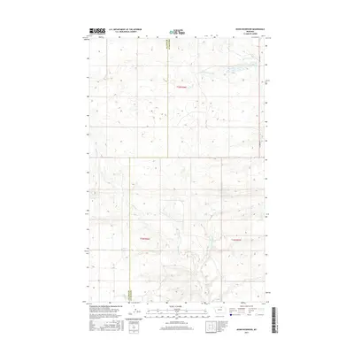
2017 Map of Down Reservoir
USGS Topo · Published 2017About this map
Down Reservoir and the drainage network of the Milk River basin define this arid section of the Montana high plains. The terrain is marked by the meandering paths of Dodson Cr and its northern branch, N Fork Dodson Cr, which carve subtle coulees through the townships of t33n r26e, t32n r26e, and t32n r27e. The landscape is largely defined by the county line between Blaine Co and Phillips Co, which bisects the quadrangle vertically. The sparse infrastructure consists primarily of section-line cattle guards and the gravel path of N Dodson Rd, reflecting the region's enduring character as open rangeland and vital watershed for local livestock operations.
Find a feature on this map
8 named features on this map. Tap any name to fly to it.
Don’t see what you’re looking for? This feature index may not catch every label — zoom into the map to look around manually.
Map Details
Editions of this 2017 Down Reservoir Map
This is the sole edition of this map. No revisions or reprints were ever made.
Other maps of this area

1920 · Avery
USGS Topo · 1:125,000

1953 · Havre
USGS Topo · 1:250,000

1957 · Havre
USGS Topo · 1:250,000

1958 · Havre
USGS Topo · 1:250,000

1964 · Coburg
USGS Topo · 1:24,000

1964 · Dodson
USGS Topo · 1:24,000

1964 · Dodson Dam
USGS Topo · 1:24,000

1984 · Emerick Bench
USGS Topo · 1:24,000
1984 · Hubert Hill SW
USGS Topo · 1:24,000
1984 · Down Reservoir NW
USGS Topo · 1:24,000