1899 Map of Downey
USGS Topo · Published 1899About this map
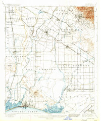
Long Beach and Alamitos Beach anchor the coastline of this late 19th-century landscape, a coastal plain defined by the expansive remnants of Spanish and Mexican land grants. Large tracts like Los Cerritos, Los Alamitos, and Santa Gertrudes still dominate the map, though the early stages of modern development are evident in the dense street grid of Whittier and the growth around Signal Hill. The era's transportation network is captured in detail, showing the Atchison Topeka and Santa Fe R.R. and several branches of the Southern Pacific R.R. linking small agricultural outposts.
Find a feature on this map
72 named features on this map. Tap any name to fly to it.
Don’t see what you’re looking for? This feature index may not catch every label — zoom into the map to look around manually.
Map Details
Editions of this 1899 Downey Map
This is the sole edition of this map. No revisions or reprints were ever made.
Historical Maps of Willowville Through Time
5 maps found