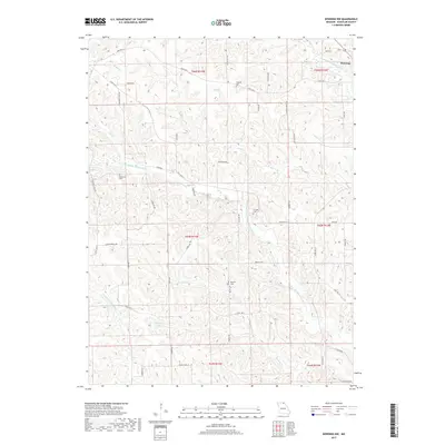
2017 Map of Downing NW
USGS Topo · Published 2017About this map
Downing sits at the northeastern edge of this Northeast Missouri landscape, where the prairie begins to break into the drainage systems of the Fabius River. The map detail highlights a rural community anchored by small family cemeteries and crossroads like Germania, located along Germania Rd. The terrain is defined by the winding paths of the S Fork Middle Fabius River and the N Fork S Fabius River, which create a complex network of ridges and creek bottoms including Bridge Cr and Brushy Cr. Scattered throughout these uplands are several burial grounds that serve as vital touchstones for local genealogy, including Germania Cem, Webster Cem, Crowder Cem, and Brushy Cem. The presence of Starbuck Lake and named elevations like D & D Ridge reflect a landscape shaped by agricultural use and the natural hydrology of Schuyler County.
Find a feature on this map
51 named features on this map. Tap any name to fly to it.
Don’t see what you’re looking for? This feature index may not catch every label — zoom into the map to look around manually.
Map Details
Editions of this 2017 Downing NW Map
This is the sole edition of this map. No revisions or reprints were ever made.
Other maps of this area

1903 · Edina
USGS Topo · 1:125,000

1911 · Queen City
USGS Topo · 1:62,500

1913 · Queen City
USGS Topo · 1:62,500

1954 · Centerville
USGS Topo · 1:250,000

1957 · Centerville
USGS Topo · 1:250,000

1958 · Centerville
USGS Topo · 1:250,000

1965 · Downing NW
USGS Topo · 1:24,000

1966 · Downing
USGS Topo · 1:24,000
1966 · Bible Grove
USGS Topo · 1:24,000
1966 · Willmathsville
USGS Topo · 1:24,000