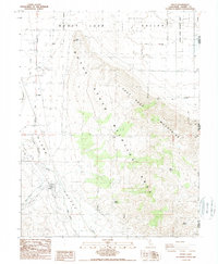
1988 Map of Doyle
USGS Topo · Published 1989About this map
The high desert landscape of Honey Lake Valley meets the rising terrain of the Fort Sage Mountains on this 1980s provisional study of eastern Lassen County. The small settlement of Doyle serves as a focal point in Long Valley, situated near the critical corridor of Long Valley Creek. This area illustrates the late 20th-century management of the basin, dominated by the expansive Doyle State Wildlife Area and marked by the remnants of earlier transportation networks like the Old RR Grade.
Find a feature on this map
17 named features on this map. Tap any name to fly to it.
Don’t see what you’re looking for? This feature index may not catch every label — zoom into the map to look around manually.
Map Details
Editions of this 1988 Doyle Map
2 editions found
Other maps of this area

1886 · Honey Lake
USGS Topo · 1:250,000

1886 · Granite Range
USGS Topo · 1:250,000

1890 · Sierraville
USGS Topo · 1:125,000

1891 · Honey Lake
USGS Topo · 1:250,000

1891 · Reno
USGS Topo · 1:125,000

1892 · Sierraville
USGS Topo · 1:125,000

1893 · Honey Lake
USGS Topo · 1:250,000

1893 · Reno
USGS Topo · 1:125,000

1894 · Granite Range
USGS Topo · 1:250,000

1894 · Sierraville
USGS Topo · 1:125,000