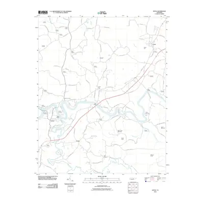
2010 Map of Doyle
USGS Topo · Published 2010About this map
Caney Fork and the Rocky River dominate this Central Tennessee landscape, where the confluence at Great Falls Dam marks a significant topographical and industrial junction. The map reveals a dense network of rural post offices that once anchored local life, including Rock Island, Walling, Quebec, and the Bone Cave Post Office. This area is particularly rich in genealogical data, preserving the locations of numerous family and community burial grounds such as Mount Pisgah Cemetery, Simrell Cemetery, and O'Neal Cemetery. High ground is defined by distinctive peaks like Bone Cave Mountain, Dukes Mountain, and Tandy Knob, while recreational history is represented by the river-adjacent grounds of Camp Boxwell and Camp Clements. Transport across the waterways is facilitated by local landmarks like Tosh Bridge and Reno Bridge, linking the settled area of Doyle with the surrounding agricultural and timber lands.
Find a feature on this map
104 named features on this map. Tap any name to fly to it.
Don’t see what you’re looking for? This feature index may not catch every label — zoom into the map to look around manually.
Map Details
Editions of this 2010 Doyle Map
This is the sole edition of this map. No revisions or reprints were ever made.
Other maps of this area

1892 · Pikeville
USGS Topo · 1:125,000

1893 · Mc Minnville
USGS Topo · 1:125,000

1895 · Mc Minnville
USGS Topo · 1:125,000

1895 · Pikeville
USGS Topo · 1:125,000

1943 · Cookeville
USGS Topo · 1:100,000

1944 · Cookeville
USGS Topo · 1:100,000

1953 · Chattanooga
USGS Topo · 1:250,000

1954 · Sparta
USGS Topo · 1:24,000
1954 · Spencer
USGS Topo · 1:24,000
1956 · Bald Knob
USGS Topo · 1:24,000