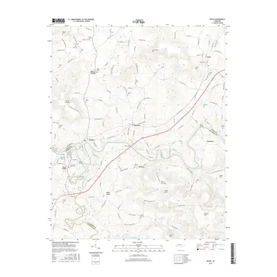
2016 Map of Doyle
USGS Topo · Published 2016About this map
Caney Fork and the Collins River converge near Rock Island, defining a landscape where the borders of White, Warren, and Van Buren counties meet. This 2016 survey highlights a region shaped by its waterways, featuring Great Falls Lake and numerous tributaries like Laurel Creek and Little Double Br. The map detail is particularly useful for genealogists, as it documents a high density of rural burial grounds, including the Old Jericho Cem, Mount Pisgah Cem, and McElroy Cem. Transportation across this undulating terrain is facilitated by structures such as Tosh Bridge and the Reno Bridge, connecting established settlements like Quebeck, Doyle, and Walling. From the elevation of Doyle Hill to the banks of the Rocky River, the map preserves the mid-2010s layout of this Tennessee river country, capturing the placement of small communities and family-named landmarks.
Find a feature on this map
144 named features on this map. Tap any name to fly to it.
Don’t see what you’re looking for? This feature index may not catch every label — zoom into the map to look around manually.
Map Details
Editions of this 2016 Doyle Map
This is the sole edition of this map. No revisions or reprints were ever made.
Other maps of this area

1892 · Pikeville
USGS Topo · 1:125,000

1893 · Mc Minnville
USGS Topo · 1:125,000

1895 · Mc Minnville
USGS Topo · 1:125,000

1895 · Pikeville
USGS Topo · 1:125,000

1943 · Cookeville
USGS Topo · 1:100,000

1944 · Cookeville
USGS Topo · 1:100,000

1953 · Chattanooga
USGS Topo · 1:250,000

1954 · Sparta
USGS Topo · 1:24,000
1954 · Spencer
USGS Topo · 1:24,000
1956 · Bald Knob
USGS Topo · 1:24,000