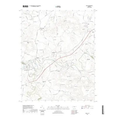
2019 Map of Doyle
USGS Topo · Published 2019About this map
Bone Cave and the surrounding highlands at the junction of White, Warren, and Van Buren Counties define this rural landscape. The map centers on the community of Quebeck, where the Mcminnville Hwy intersects a network of local routes like Holder Station Rd. The topography is shaped by the winding course of the Caney Fork and the Collins River, which meet near the settlement of Rock Island. Numerous family-named landmarks and cemeteries, such as Mount Pisgah Cem and Old Jericho Cem, provide deep genealogical context for the area. The landscape transitions from the river bottoms to significant elevations like Bone Cave Mtn and Mitchell Knob, reflecting the rugged transition between the valley floor and the surrounding plateaus. Smaller settlements like Walling, McElroy, and Sparkman are connected by historic crossings, including Tosh Bridge and Reno Bridge.
Find a feature on this map
82 named features on this map. Tap any name to fly to it.
Don’t see what you’re looking for? This feature index may not catch every label — zoom into the map to look around manually.
Map Details
Editions of this 2019 Doyle Map
This is the sole edition of this map. No revisions or reprints were ever made.
Other maps of this area

1892 · Pikeville
USGS Topo · 1:125,000

1893 · Mc Minnville
USGS Topo · 1:125,000

1895 · Mc Minnville
USGS Topo · 1:125,000

1895 · Pikeville
USGS Topo · 1:125,000

1943 · Cookeville
USGS Topo · 1:100,000

1944 · Cookeville
USGS Topo · 1:100,000

1953 · Chattanooga
USGS Topo · 1:250,000

1954 · Sparta
USGS Topo · 1:24,000
1954 · Spencer
USGS Topo · 1:24,000
1956 · Bald Knob
USGS Topo · 1:24,000