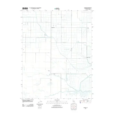
2012 Map of Dozier
USGS Topo · Published 2012About this map
Agricultural flatlands and winding delta waterways characterize this portion of Solano County, where a grid of irrigation-focused rural roads connects several small settlements. The community of Binghamton sits at a crossroads in the north, while the southern landscape is defined by the complex hydrology of Barker Slough and the man-made Calhoun Cut. These water features, alongside Lindsey Slough and Maine Prairie Slough, illustrate the intricate relationship between the region's ranching operations and the Sacramento River Delta's water management systems. Smaller locales like Dozier, Olcott, and Vale are scattered along these routes, serving as vital nodes for the surrounding farms. The eastern edge of the map shows the transition into more frequent sloughs, including Haas Slough and Cache Slough, highlighting the watery boundary of Maine Prairie. This survey captures the enduring rural character of the area, where historical ranch names like Campbell Ranch remain prominent markers of the local geography.
Find a feature on this map
35 named features on this map. Tap any name to fly to it.
Don’t see what you’re looking for? This feature index may not catch every label — zoom into the map to look around manually.
Map Details
Editions of this 2012 Dozier Map
This is the sole edition of this map. No revisions or reprints were ever made.
Other maps of this area

1907 · Antioch
USGS Topo · 1:62,500

1908 · Vacaville
USGS Topo · 1:62,500

1908 · Courtland
USGS Topo · 1:62,500

1908 · Antioch
USGS Topo · 1:62,500

1910 · Rio Vista
USGS Topo · 1:31,680

1916 · Dixon
USGS Topo · 1:31,680

1916 · Cache Slough
USGS Topo · 1:31,680

1916 · Maine Prairie
USGS Topo · 1:31,680
1916 · Saxon
USGS Topo · 1:31,680

1917 · Wolfskill
USGS Topo · 1:31,680