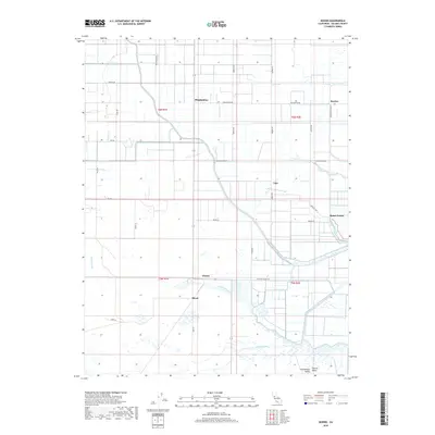
2018 Map of Dozier
USGS Topo · Published 2018About this map
Binghamton and the crossroads of Dozier anchor this section of the Sacramento Valley, where the agricultural landscape of Solano County meets the complex hydrology of the delta. The terrain is defined by a intricate system of irrigation and natural drainage, including Sweany Creek, Alamo Cr, and the slow-moving waters of Barker Slough. To the east, the settlement of Maine Prairie sits near the confluence of Maine Prairie Slough and Cache Slough, marking an area historically vital for water-based transport. A network of named local roads like Pedrick Rd and Maine Prairie Rd connects these rural hubs, while artificial waterways such as Calhoun Cut and Hastings Cut demonstrate the engineered nature of the contemporary Central Valley landscape. This survey documents the persistent grid of the Public Land Survey System, overlaid upon a basin where sloughs and creeks still dictate the placement of ranches and small communities.
Find a feature on this map
42 named features on this map. Tap any name to fly to it.
Don’t see what you’re looking for? This feature index may not catch every label — zoom into the map to look around manually.
Map Details
Editions of this 2018 Dozier Map
This is the sole edition of this map. No revisions or reprints were ever made.
Other maps of this area

1907 · Antioch
USGS Topo · 1:62,500

1908 · Vacaville
USGS Topo · 1:62,500

1908 · Courtland
USGS Topo · 1:62,500

1908 · Antioch
USGS Topo · 1:62,500

1910 · Rio Vista
USGS Topo · 1:31,680

1916 · Dixon
USGS Topo · 1:31,680

1916 · Cache Slough
USGS Topo · 1:31,680

1916 · Maine Prairie
USGS Topo · 1:31,680
1916 · Saxon
USGS Topo · 1:31,680

1917 · Wolfskill
USGS Topo · 1:31,680