
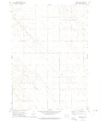
1972 Map of Draper
USGS Topo · Published 1975About this map
Draper serves as the central hub of this Jones County landscape, situated where the tracks of the Chicago Milwaukee St Paul and Pacific railroad intersect the local road network. The settlement pattern is tightly clustered around the rail line, a common characteristic of South Dakota prairie towns that relied on the iron road for transport and commerce. Outside the town limits, the terrain is shaped by the drainages of Medicine Creek and Bull Creek, which provide the primary hydrological structure for the surrounding agricultural sections. Evidence of local infrastructure and land management is visible in the presence of the Draper Dam and the Sewage Disp Pond just south of the main township. For those tracing family history, the Draper Cem is clearly marked to the northwest of the village, while township boundaries like Lincoln and Draper provide a clear framework for identifying historic land parcels.
Find a feature on this map
17 named features on this map. Tap any name to fly to it.
Don’t see what you’re looking for? This feature index may not catch every label — zoom into the map to look around manually.
Map Details
Editions of this 1972 Draper Map
This is the sole edition of this map. No revisions or reprints were ever made.
Other maps of this area

1951 · Murdo SE
USGS Topo · 1:24,000

1951 · Murdo SW
USGS Topo · 1:24,000

1954 · Pierre
USGS Topo · 1:250,000

1955 · Martin
USGS Topo · 1:250,000

1958 · Pierre
USGS Topo · 1:250,000

1958 · Martin
USGS Topo · 1:250,000

1970 · Vivian SW
USGS Topo · 1:24,000

1972 · Pierre 3 SW
USGS Topo · 1:24,000

1972 · Murdo
USGS Topo · 1:24,000
1972 · Wendte SE
USGS Topo · 1:24,000