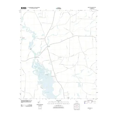
2011 Map of Drayton
USGS Topo · Published 2011About this map
Drayton and its surrounding wetlands sit at the heart of this landscape where the Flint River transitions into the upper reaches of Lake Blackshear. The map reveals a rural Georgia topography defined by complex water systems, including the meandering Turkey Creek and Pennahatchee Creek, which feed into the reservoir. This hydrology has historically shaped movement through Dooly County, as evidenced by the Luther Storey Bridge crossing the river and several bluffs like Pennys Bluff and Danville Bluff that overlook the swampy bottoms. Genealogy researchers will find significant value in the distribution of family and community burial grounds, such as Macedonia Cemetery, Collier Cemetery, and Springhill Cemetery. The presence of landmarks like Whisky Island and Smokehouse Point suggests a long history of local lore and seasonal activity along the river’s edge, while the grid of unpaved roads like Slosheye Trl connects the scattered homesteads of this agricultural region.
Find a feature on this map
63 named features on this map. Tap any name to fly to it.
Don’t see what you’re looking for? This feature index may not catch every label — zoom into the map to look around manually.
Map Details
Editions of this 2011 Drayton Map
This is the sole edition of this map. No revisions or reprints were ever made.
Other maps of this area

1953 · Dothan
USGS Topo · 1:250,000

1953 · Waycross
USGS Topo · 1:250,000

1954 · Dothan
USGS Topo · 1:250,000

1955 · Dothan
USGS Topo · 1:250,000

1955 · Phenix City
USGS Topo · 1:250,000

1956 · Leslie
USGS Topo · 1:62,500

1957 · Phenix City
USGS Topo · 1:250,000

1957 · Macon
USGS Topo · 1:250,000

1958 · Macon
USGS Topo · 1:250,000

1958 · Phenix City
USGS Topo · 1:250,000