
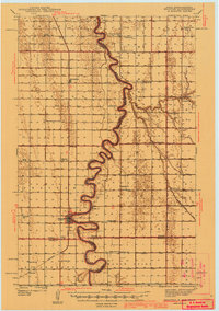
1941 Map of Drayton
USGS Topo · Published 1941About this map
The meandering Red River of the North defines the borderland between North Dakota and Minnesota, carving deep loops through the flat agricultural expanse of the Red River Valley. In this 1939 survey, the landscape is heavily engineered for drainage, as evidenced by an extensive network of ditches including Judicial Ditch No 10 and County Ditch No 6. The Northern Pacific railroad runs parallel to the river on the North Dakota side, anchoring the growth of settlements like Drayton, Bowesmont, and Herrick. The map reveals a densely settled rural community served by numerous neighborhood schools and churches, such as Skjeberg Ch, Lincoln Sch, and Willow Grove Sch. Regional infrastructure is further noted by the Airway Beacon near Drayton and the Township Hall in the eastern townships, illustrating the organized civic and transport life of the late depression era.
Find a feature on this map
45 named features on this map. Tap any name to fly to it.
Don’t see what you’re looking for? This feature index may not catch every label — zoom into the map to look around manually.
Map Details
Editions of this 1941 Drayton Map
2 editions found
Other maps of this area

1918 · Acton
USGS Topo · 1:62,500

1918 · Argyle
USGS Topo · 1:62,500

1939 · Drayton
USGS Topo · 1:62,500

1939 · Glasston
USGS Topo · 1:62,500

1939 · Pembina
USGS Topo · 1:62,500

1939 · Kennedy
USGS Topo · 1:62,500

1941 · Kennedy
USGS Topo · 1:62,500

1941 · Glasston
USGS Topo · 1:62,500

1941 · Hallock
USGS Topo · 1:62,500

1941 · Bathgate
USGS Topo · 1:62,500