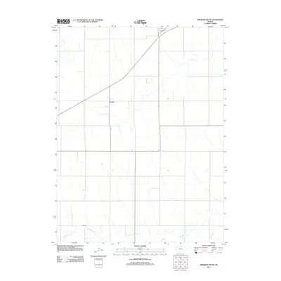
2012 Map of Dresden South
USGS Topo · Published 2012About this map
Leoville sits as the central point of interest in this Decatur County landscape, an area defined by the high plains of northwest Kansas. The terrain is structured by a rectilinear grid of local routes, including Kings Ave and Railroad St, which serve the agricultural outskirts. Flowing across the southern portion of the sheet, the N Fork Solomon River provides a natural break in the geometric road pattern, its winding path indicating the drainage system of the Solomon Valley. The map also documents modern infrastructure such as Co Rd-370, showing how late 20th and early 21st-century developments overlay the traditional township and range survey lines. This 2012 survey by the U.S. Geological Survey offers a clear look at the contemporary rural layout and water resources of the Dresden South area.
Find a feature on this map
5 named features on this map. Tap any name to fly to it.
Don’t see what you’re looking for? This feature index may not catch every label — zoom into the map to look around manually.
Map Details
Editions of this 2012 Dresden South Map
This is the sole edition of this map. No revisions or reprints were ever made.
Other maps of this area

1951 · Selden
USGS Topo · 1:62,500

1954 · Goodland
USGS Topo · 1:250,000

1956 · Goodland
USGS Topo · 1:250,000

1957 · Goodland
USGS Topo · 1:250,000
1965 · Selden NE
USGS Topo · 1:24,000
1978 · Dresden North
USGS Topo · 1:24,000
1978 · Jennings
USGS Topo · 1:24,000

1978 · Allison
USGS Topo · 1:24,000

1978 · Selden
USGS Topo · 1:24,000

1978 · Dresden South
USGS Topo · 1:24,000