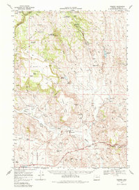
1968 Map of Drewsey
USGS Topo · Published 1984About this map
The Drewsey Valley serves as the central hub of this eastern Oregon landscape, where the Malheur River flows through a region defined by high desert ranching and water management. Recorded in the late 1960s, the map reveals a complex system of irrigation and land use, featuring the Drewsey Company Ditch and several livestock-supporting water sources like Stallard Reservoir and Riley Reservoir. To the north, the terrain rises into the Malheur National Forest, where volcanic features such as Merlie Butte and Hald Butte overlook the Otis Basin. Geologists and researchers will find numerous Prospects and Borrow Pits scattered near Drewsey and Kingsbury, reflecting the localized resource extraction of the era. The presence of the Gaging Station on the river and various named flats, including Kimball Flat and Miller Flat, underscores a landscape carefully partitioned for reclamation and grazing.
Find a feature on this map
65 named features on this map. Tap any name to fly to it.
Don’t see what you’re looking for? This feature index may not catch every label — zoom into the map to look around manually.
Map Details
Editions of this 1968 Drewsey Map
2 editions found
Other maps of this area

1908 · Ironside Mountain
USGS Topo · 1:125,000

1955 · Burns
USGS Topo · 1:250,000

1955 · Canyon City
USGS Topo · 1:250,000

1958 · Burns
USGS Topo · 1:250,000

1959 · Burns
USGS Topo · 1:250,000

1959 · Canyon City
USGS Topo · 1:250,000

1961 · Logan Valley
USGS Topo · 1:62,500

1966 · Beulah
USGS Topo · 1:62,500

1968 · Drewsey
USGS Topo · 1:62,500

1968 · Van
USGS Topo · 1:62,500