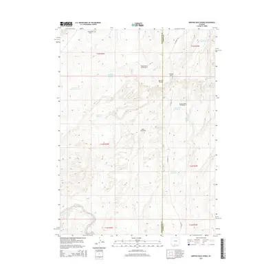
2015 Map of Dripping Rock Spring
USGS Topo · Published 2015About this map
Courthouse Butte dominates the northern horizon of this high-desert landscape on the border of Sweetwater and Carbon counties. This environment is characterized by a sophisticated network of water management features, including the Continental Reservoir Number 1 and Dripping Rock Reservoir, which highlight the essential role of water collection in the arid West. The presence of Hartt Cabin Spring and Hartt Cabin Draw suggests a history of cattle ranching or early homesteading, while Dripping Rock Pit Number 2 indicates localized industrial activity. The terrain is defined by dramatic drainage patterns such as South Barrel Springs Draw and Hangout Wash, providing a clear record of the geological forces shaping the area's plateaus and ridges, including the prominent West Flat Top Mtn.
Find a feature on this map
26 named features on this map. Tap any name to fly to it.
Don’t see what you’re looking for? This feature index may not catch every label — zoom into the map to look around manually.
Map Details
Editions of this 2015 Dripping Rock Spring Map
This is the sole edition of this map. No revisions or reprints were ever made.
Other maps of this area

1954 · Rawlins
USGS Topo · 1:250,000

1954 · Rock Springs
USGS Topo · 1:250,000

1958 · Rawlins
USGS Topo · 1:250,000

1958 · Rock Springs
USGS Topo · 1:250,000

1962 · Rawlins
USGS Topo · 1:250,000

1962 · Rock Springs
USGS Topo · 1:250,000

1967 · Rawlins
USGS Topo · 1:250,000

1970 · South Barrel Spring
USGS Topo · 1:24,000

1970 · Mexican Flats
USGS Topo · 1:24,000
1970 · Powder Mountain NE
USGS Topo · 1:24,000