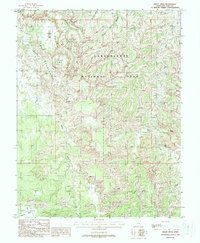
1988 Map of Druid Arch
USGS Topo · Published 1988About this map
Canyonlands National Park dominates this late-twentieth-century landscape, showcasing the intricate erosion patterns of the Colorado Plateau in San Juan County. The topography is defined by the labyrinthine spires of The Needles, where isolated grassy clearings like Chesler Park and Virginia Park are enclosed by sandstone formations. Geological landmarks such as Druid Arch and Angel Arch highlight the unique structural features of the area, while the drainage systems of Elephant Canyon, Squaw Canyon, and Salt Creek reveal the network of ephemeral waterways that have carved this environment over millennia. To the south, the transition into Beef Basin and Middle Park suggests a shift toward broader, though no less complex, canyon floor terrain. Remote access is indicated by various 4wd routes, connecting significant water sources such as Peekaboo Spring and topographical breaks like the Upper Jump along the creek beds.
Find a feature on this map
19 named features on this map. Tap any name to fly to it.
Don’t see what you’re looking for? This feature index may not catch every label — zoom into the map to look around manually.
Map Details
Editions of this 1988 Druid Arch Map
2 editions found
Other maps of this area

1885 · La Sal
USGS Topo · 1:250,000

1886 · Abajo
USGS Topo · 1:250,000

1892 · Abajo
USGS Topo · 1:250,000

1893 · Abajo
USGS Topo · 1:250,000

1935 · Elk Ridge
USGS Topo · 1:96,000

1940 · Elk Ridge
USGS Topo · 1:125,000

1953 · Carlisle 3 NW
USGS Topo · 1:24,000

1953 · The Needles
USGS Topo · 1:62,500

1954 · Elk Ridge 1 NW
USGS Topo · 1:24,000

1954 · Carlisle 4 SW
USGS Topo · 1:24,000