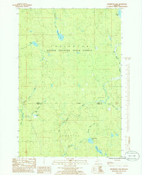
1985 Map of Drummond Lake
USGS Topo · Published 1986About this map
Copper Country State Forest dominates this section of the Upper Peninsula, where the landscape is defined by the complex hydrology of the Baraga and Iron county line. The drainage patterns of the Murphy River and East Branch Net River illustrate a territory defined by timber and water rather than dense urbanization. Small, isolated clearings such as Fox Farm and a simple Farm label suggest localized agricultural attempts or specialized husbandry in a region otherwise dominated by forest cover. A dense concentration of small water bodies, including Drummond Lake, Little Pickerel Lake, and Hemlock Lake, points to the glacial history of this terrain. This 1985 provisional study captures the area before modern development, preserving the location of family-named landmarks and the precise boundary lines between the Covington and Hematite townships.
Find a feature on this map
21 named features on this map. Tap any name to fly to it.
Don’t see what you’re looking for? This feature index may not catch every label — zoom into the map to look around manually.
Map Details
Editions of this 1985 Drummond Lake Map
This is the sole edition of this map. No revisions or reprints were ever made.
Other maps of this area

1895 · Ned Lake
USGS Topo · 1:62,500

1895 · Perch Lake
USGS Topo · 1:62,500

1954 · Perch Lake
USGS Topo · 1:62,500

1954 · Sidnaw
USGS Topo · 1:62,500

1955 · Ned Lake
USGS Topo · 1:62,500

1955 · Herman
USGS Topo · 1:62,500

1958 · Iron River
USGS Topo · 1:250,000

1960 · Iron River
USGS Topo · 1:250,000

1961 · Iron River
USGS Topo · 1:250,000

1967 · Iron River
USGS Topo · 1:250,000