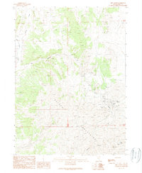
1989 Map of Dry Canyon
USGS Topo · Published 1989About this map
The Delano Mountains define this high-altitude mining landscape in northeast Elko County, where the late 1980s topography reveals a complex network of resource extraction. Concentrated primarily in the southern reach of Dry Canyon, the district is anchored by the Delano Mines and the Cleveland Mine, surrounded by numerous prospect pits and adits that speak to the area's silver and lead heritage. The terrain is marked by significant elevation changes, from the heights of Mine Mountain to the depths of Division Canyon. Water sources like Rock Spring, Delano Well, and Cold Spring appear as vital points in an otherwise arid expanse. This provisional survey captures the transition from traditional underground operations at the Gold Note Mine to modern surface impacts like the Open Pit Mine, providing a clear look at the industrial footprint during a period of active geological assessment in the Great Basin.
Find a feature on this map
18 named features on this map. Tap any name to fly to it.
Don’t see what you’re looking for? This feature index may not catch every label — zoom into the map to look around manually.
Map Details
Editions of this 1989 Dry Canyon Map
This is the sole edition of this map. No revisions or reprints were ever made.
Other maps of this area

1955 · Wells
USGS Topo · 1:250,000

1958 · Wells
USGS Topo · 1:250,000

1961 · Wells
USGS Topo · 1:250,000

1961 · Delano Mountains
USGS Topo · 1:62,500

1961 · Gollaher Mountain
USGS Topo · 1:62,500

1961 · Goose Creek
USGS Topo · 1:62,500

1961 · Dairy Valley
USGS Topo · 1:62,500
1980 · Dry Canyon
USGS Topo · 1:24,000

1982 · Jackpot
USGS Topo · 1:100,000
1989 · Mustang Draw
USGS Topo · 1:24,000