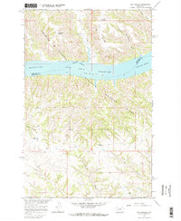
1965 Map of Dry Coulee
USGS Topo · Published 1968About this map
The Missouri River and its massive Fort Peck Reservoir dominate this 1960s landscape, where the water's edge defines the boundary between the Charles M Russell National Wildlife Range and the rugged northern breaks. The map captures a moment when land use was transitioning from traditional ranching to federal conservation management. Settled life is represented by specific family landmarks such as the McArthur Ranch, Novak Homestead, and Woods Place, providing essential touchstones for genealogists tracking early twentieth-century residents. The terrain is deeply incised by countless drainage features like Blacktail Coulee and Fisher Coulee, while man-made improvements like the Timber Pit Reservoir and Big Rock Reservoir illustrate the critical importance of water management in this semi-arid environment.
Find a feature on this map
21 named features on this map. Tap any name to fly to it.
Don’t see what you’re looking for? This feature index may not catch every label — zoom into the map to look around manually.
Map Details
Editions of this 1965 Dry Coulee Map
2 editions found
Other maps of this area

1954 · Lewistown
USGS Topo · 1:250,000

1959 · Lewistown
USGS Topo · 1:250,000

1965 · Karsten Coulee
USGS Topo · 1:24,000

1965 · Dry Coulee
USGS Topo · 1:24,000

1965 · Chain Buttes
USGS Topo · 1:24,000
1965 · Weingart Place
USGS Topo · 1:24,000

1965 · Lake Reservoir
USGS Topo · 1:24,000

1965 · Weingart Place NW
USGS Topo · 1:24,000

1971 · Blizzard Reservoir
USGS Topo · 1:24,000

1971 · Hanson Flat
USGS Topo · 1:24,000