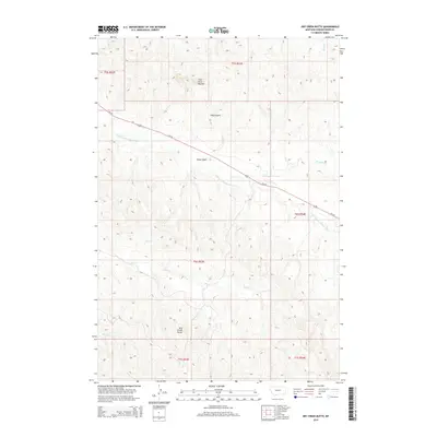
2014 Map of Dry Creek Butte
USGS Topo · Published 2014About this map
Dry Creek Butte and the East Fork Buttes anchor this high-plains landscape in Powder River County, where the terrain is defined by a dense network of seasonal drainages and coulees. The map highlights a significant segment of the E Fork Little Powder River, which winds northwestward through the central portion of the quadrangle. This watercourse, along with its tributaries like Burdette Cr and Flat Cr, illustrates the drainage patterns typical of southeastern Montana's ranching country. Human infrastructure is primarily represented by Us-212, a major transit route that cuts diagonally across the northern half of the survey, crossing Olson Gulch as it connects this isolated region to the broader road network. The lack of concentrated settlements emphasizes the open-range character of the land during this period, with the topography being the primary feature for local navigation.
Find a feature on this map
17 named features on this map. Tap any name to fly to it.
Don’t see what you’re looking for? This feature index may not catch every label — zoom into the map to look around manually.
Map Details
Editions of this 2014 Dry Creek Butte Map
This is the sole edition of this map. No revisions or reprints were ever made.
Other maps of this area

1954 · Ekalaka
USGS Topo · 1:250,000

1956 · Ekalaka
USGS Topo · 1:250,000

1958 · Ekalaka
USGS Topo · 1:250,000

1965 · Ekalaka
USGS Topo · 1:250,000

1970 · Pine Creek
USGS Topo · 1:24,000

1970 · Sanburn Reservoir
USGS Topo · 1:24,000
1970 · Belle Creek North
USGS Topo · 1:24,000

1973 · Monday Creek
USGS Topo · 1:24,000
1973 · Fighting Butte
USGS Topo · 1:24,000

1980 · Broadus
USGS Topo · 1:100,000