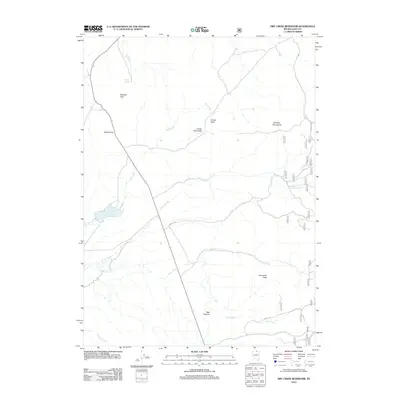
2012 Map of Dry Creek Reservoir
USGS Topo · Published 2012About this map
The high desert landscape of Elko County is defined by the hydrologic network feeding into Dry Creek Reservoir, a vital water source in this arid region of Nevada. The eastern portion of the sheet is dominated by the Bull Run Mountains, where drainage systems like Sheep Creek and Indian Creek descend toward the valley floor. Notable local landmarks such as Crows Nest and White Gate mark the few established points of interest along the limited road network, which includes several National Forest Development routes like NFD 178 RD. To the south, the terrain becomes increasingly complex around Porcupine Pass and the steep incisions of Wall Canyon, providing a clear view of the geographic barriers that shaped ranching and transport in this part of the state during the early 21st century.
Find a feature on this map
19 named features on this map. Tap any name to fly to it.
Don’t see what you’re looking for? This feature index may not catch every label — zoom into the map to look around manually.
Map Details
Editions of this 2012 Dry Creek Reservoir Map
This is the sole edition of this map. No revisions or reprints were ever made.
Other maps of this area

1939 · Owyhee
USGS Topo · 1:62,500

1942 · Owyhee
USGS Topo · 1:62,500

1955 · McDermitt
USGS Topo · 1:250,000

1956 · Bull Run
USGS Topo · 1:62,500

1959 · McDermitt
USGS Topo · 1:250,000

1964 · Hat Peak
USGS Topo · 1:62,500

1964 · Wilson Reservoir
USGS Topo · 1:62,500
1970 · Ungina Wongo
USGS Topo · 1:24,000
1971 · Owyhee
USGS Topo · 1:24,000
1971 · The Point
USGS Topo · 1:24,000