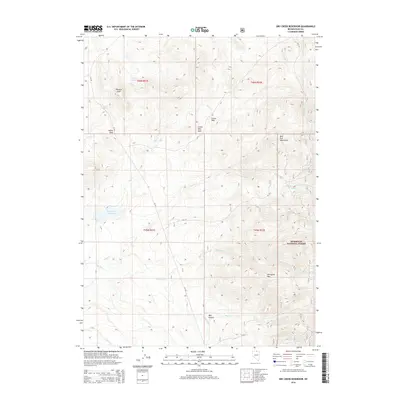
2015 Map of Dry Creek Reservoir
USGS Topo · Published 2015About this map
Dry Creek Reservoir anchors the western edge of this High Desert landscape, where the high-altitude terrain of Elko County rises into the Bull Run Mountains. The map reveals a network of water management and seasonal drainage, from the Homer Ditch in the south to the upper reaches of Dry Creek and Indian Creek. Settlement is sparse and specialized, marked by points like Paisewa Goei and the aptly named Crows Nest.
Find a feature on this map
25 named features on this map. Tap any name to fly to it.
Don’t see what you’re looking for? This feature index may not catch every label — zoom into the map to look around manually.
Map Details
Editions of this 2015 Dry Creek Reservoir Map
This is the sole edition of this map. No revisions or reprints were ever made.
Other maps of this area

1939 · Owyhee
USGS Topo · 1:62,500

1942 · Owyhee
USGS Topo · 1:62,500

1955 · McDermitt
USGS Topo · 1:250,000

1956 · Bull Run
USGS Topo · 1:62,500

1959 · McDermitt
USGS Topo · 1:250,000

1964 · Hat Peak
USGS Topo · 1:62,500

1964 · Wilson Reservoir
USGS Topo · 1:62,500
1970 · Ungina Wongo
USGS Topo · 1:24,000
1971 · Owyhee
USGS Topo · 1:24,000
1971 · The Point
USGS Topo · 1:24,000