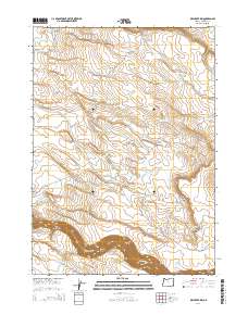
2014 Map of Dry Creek Rim
USGS Topo · Published 2014About this map
The Owyhee River snakes through the southern edge of this Oregon landscape, carving the deep Owyhee Canyon through the high desert plateau. This 2014 survey captures a remote section of Malheur County dominated by the prominent Dry Creek Rim and the curious depression known as Hole in the Ground. The area's agricultural and ranching foundations are evident in the density of small-scale water management features, including Little John Reservoir, Eiguren Reservoir, and Fretwell Reservoir. Local transportation is defined by primitive and secondary routes like Arritola Place Rd and the Grassy Mountain Loop, which provide access to this arid environment. The presence of the S Side Canal and numerous named catchments like Dead Horse Reservoir highlights the critical role of water diversion in this high-altitude cattle country.
Find a feature on this map
22 named features on this map. Tap any name to fly to it.
Don’t see what you’re looking for? This feature index may not catch every label — zoom into the map to look around manually.
Map Details
Editions of this 2014 Dry Creek Rim Map
This is the sole edition of this map. No revisions or reprints were ever made.
Other maps of this area

1955 · Jordan Valley
USGS Topo · 1:250,000

1957 · Jordan Valley
USGS Topo · 1:250,000

1958 · Jordan Valley
USGS Topo · 1:250,000
1969 · Little Grassy Mountain
USGS Topo · 1:24,000
1969 · Threemile Hill
USGS Topo · 1:24,000
1969 · Dry Creek Rim
USGS Topo · 1:24,000
1969 · Danner
USGS Topo · 1:24,000
1972 · Scott Reservoir
USGS Topo · 1:24,000
1972 · Arock
USGS Topo · 1:24,000

1979 · Rockhouse Reservoir
USGS Topo · 1:24,000