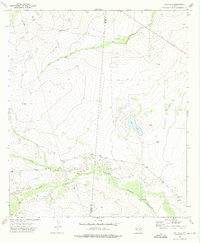
1973 Map of Dry Lake
USGS Topo · Published 1976About this map
The arid ranchlands of the Culberson and Reeves County line are captured in this early 1970s topographical study. Water management is the central theme of this landscape, evidenced by the presence of an Aqueduct and the remote Juan Windmill. The terrain is defined by seasonal drainage systems such as Dutch Draw and Incline Draw, which feed toward the ephemeral Dry Lake basin. Human activity is sparse, clustered primarily at the Derrick Ranch and small extractive sites like the Gravel Pits. A notable Drill Hole in the central east suggests exploratory activity in this corner of the Trans-Pecos, where the elevation changes and alluvial fans of Cottonwood Creek dictate the layout of fences and unimproved roads.
Find a feature on this map
11 named features on this map. Tap any name to fly to it.
Don’t see what you’re looking for? This feature index may not catch every label — zoom into the map to look around manually.
Map Details
Editions of this 1973 Dry Lake Map
This is the sole edition of this map. No revisions or reprints were ever made.
Other maps of this area

1921 · Toyah
USGS Topo · 1:125,000

1928 · Kent
USGS Topo · 1:125,000

1954 · Van Horn
USGS Topo · 1:250,000

1954 · Pecos
USGS Topo · 1:250,000

1957 · Pecos
USGS Topo · 1:250,000

1958 · Van Horn
USGS Topo · 1:250,000

1968 · Threemile Draw
USGS Topo · 1:24,000

1968 · W T Ranch
USGS Topo · 1:24,000
1970 · Toyah NW
USGS Topo · 1:24,000

1973 · Rustler Hills
USGS Topo · 1:24,000