
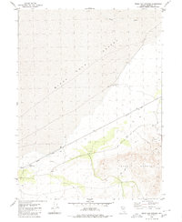
1980 Map of Dry Mountain
USGS Topo · Published 1980About this map
Dry Mountain dominates this portion of Pershing County, Nevada, as it appeared in the mid-1970s. The landscape is characterized by its high-altitude water sources and primitive transportation routes, reflecting a corner of the Great Basin defined by its seasonal hydrology and isolation. Remote water points such as Garrett Spring and Wet Weather Spring provide critical landmarks for those navigating the high terrain, where several Jeep Trails wind through the hills. This 1980 edition, based on 1974 photogrammetric data, captures the section lines and boundaries including the divide between T 33 N and T 32 N, offering a precise record of the land division and natural features in a region where few permanent settlements exist.
Find a feature on this map
5 named features on this map. Tap any name to fly to it.
Don’t see what you’re looking for? This feature index may not catch every label — zoom into the map to look around manually.
Map Details
Editions of this 1980 Dry Mountain Map
This is the sole edition of this map. No revisions or reprints were ever made.
Other maps of this area

1886 · Granite Range
USGS Topo · 1:250,000

1894 · Granite Range
USGS Topo · 1:250,000

1931 · Lovelock
USGS Topo · 1:250,000

1935 · Lovelock
USGS Topo · 1:250,000

1955 · Lovelock
USGS Topo · 1:250,000

1959 · Lovelock
USGS Topo · 1:250,000

1980 · Dry Mountain NW
USGS Topo · 1:24,000

1980 · Eagle Rock Spring
USGS Topo · 1:24,000
1980 · Trego Hot Spring
USGS Topo · 1:24,000

1980 · Tenmile
USGS Topo · 1:24,000