
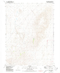
1980 Map of Eagle Rock Spring
USGS Topo · Published 1980About this map
The Lava Beds dominate the eastern reaches of this Pershing County landscape, where volcanic topography defines the high-desert environment. The presence of Lava Beds Camp and several vital water sources like Eagle Rock Spring and Mustang Spring indicates the area's importance for range management and seasonal occupation during the late 20th century. While much of the terrain is characterized by a deep Canyon and steep elevation changes, a network of tracks including a Jeep Trail and various other paths connect these isolated outposts. A single Prospect located in the southern hills points to the persistent legacy of mineral exploration that has long drawn surveyors and miners to the Nevada interior. This survey captures a moment when the utilitarian needs of ranching and exploration intersected with the prehistoric geological features of the Great Basin.
Find a feature on this map
9 named features on this map. Tap any name to fly to it.
Don’t see what you’re looking for? This feature index may not catch every label — zoom into the map to look around manually.
Map Details
Editions of this 1980 Eagle Rock Spring Map
This is the sole edition of this map. No revisions or reprints were ever made.
Other maps of this area

1886 · Granite Range
USGS Topo · 1:250,000

1894 · Granite Range
USGS Topo · 1:250,000

1931 · Lovelock
USGS Topo · 1:250,000

1935 · Lovelock
USGS Topo · 1:250,000

1955 · Lovelock
USGS Topo · 1:250,000

1959 · Lovelock
USGS Topo · 1:250,000

1980 · Dry Mountain NW
USGS Topo · 1:24,000

1980 · Dry Mountain
USGS Topo · 1:24,000

1980 · Tenmile
USGS Topo · 1:24,000
1981 · Sheep Spring
USGS Topo · 1:24,000