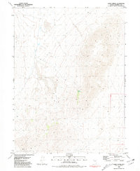
1981 Map of Sheep Spring
USGS Topo · Published 1981About this map
Lava Beds Creek winds through this arid expanse of Pershing County, Nevada, during a period of detailed mapping following field inspections in the mid-1970s. The landscape is defined by its drainage patterns and isolated water sources, most notably Sheep Spring, which serves as a vital focal point in an otherwise thirsty terrain. Economic activity in this corner of the state is anchored by the Garrett Mine, a landmark that speaks to the region's enduring mining history. This survey illustrates the sparse but critical human imprints upon the land, where townships like T 32 N and ranges such as R 28 E provide the only structural framework across the vast desert topography.
Find a feature on this map
6 named features on this map. Tap any name to fly to it.
Don’t see what you’re looking for? This feature index may not catch every label — zoom into the map to look around manually.
Map Details
Editions of this 1981 Sheep Spring Map
This is the sole edition of this map. No revisions or reprints were ever made.
Other maps of this area

1886 · Granite Range
USGS Topo · 1:250,000

1894 · Granite Range
USGS Topo · 1:250,000

1931 · Lovelock
USGS Topo · 1:250,000

1935 · Lovelock
USGS Topo · 1:250,000

1955 · Lovelock
USGS Topo · 1:250,000

1959 · Lovelock
USGS Topo · 1:250,000

1980 · Eagle Rock Spring
USGS Topo · 1:24,000
1980 · Trego Hot Spring
USGS Topo · 1:24,000

1980 · Dry Mountain
USGS Topo · 1:24,000

1981 · Gerlach
USGS Topo · 1:100,000