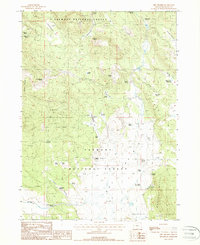
1988 Map of Dry Prairie
USGS Topo · Published 1988About this map
Fremont National Forest dominates this high-country landscape in the late 1980s, revealing a terrain shaped by volcanic geography and the critical management of water. The map detail highlights an extensive network of springs and small ponds used for livestock and forest management, such as Seven Springs, Miner Pond, and Dry Prairie No 1 Pond. These water sources are scattered across varied flats and depressions, including Yellow Jacket Flat and Willow Flat. High points like James Butte and Paddock Butte provide topographic relief, while human activity is evidenced by Murray Field and several resource extraction sites including a Quarry and a Cinder Pit. The presence of man-made features like O'Connor Reservoir and a Corral suggests a landscape defined by seasonal grazing and remote forest operations within the Gearhart Mountain region.
Find a feature on this map
45 named features on this map. Tap any name to fly to it.
Don’t see what you’re looking for? This feature index may not catch every label — zoom into the map to look around manually.
Map Details
Editions of this 1988 Dry Prairie Map
This is the sole edition of this map. No revisions or reprints were ever made.
Other maps of this area

1889 · Klamath
USGS Topo · 1:250,000

1894 · Klamath
USGS Topo · 1:250,000

1955 · Klamath Falls
USGS Topo · 1:250,000

1957 · Malin
USGS Topo · 1:62,500

1958 · Klamath Falls
USGS Topo · 1:250,000

1960 · Gerber Reservoir
USGS Topo · 1:62,500

1960 · Bly
USGS Topo · 1:62,500

1960 · Beatty
USGS Topo · 1:62,500
1988 · Gerber Reservoir
USGS Topo · 1:24,000
1988 · Yainax Butte
USGS Topo · 1:24,000